close
    • chevron_right

      Complex, volatile coast makes preparing for tsunamis tough in Alaska

      news.movim.eu / ArsTechnica · Monday, 27 November - 14:42 · 1 minute

    Tsunami damage

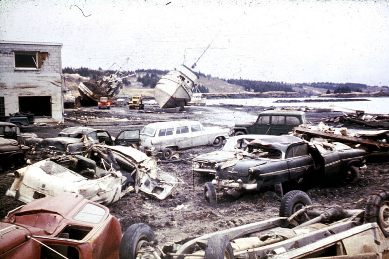
    Enlarge / Damage from the 1964 earthquake and tsunami in Kodiak, Alaska. (credit: Education Images via Getty )

    On an overcast day in September, Heidi Geagel negotiates familiar potholes on a gravel road in Seldovia, Alaska. Cresting a hill topped with a small chapel, her town spreads out below—in the bay, gently rocking fishing boats; onshore, the Linwood Bar & Grill, the Crab Pot Grocery, and a couple dozen homes on stilts.

    Geagel, Seldovia’s city manager, turns around to three people sitting in the back seat, who partner with the United States’ National Tsunami Hazard Mitigation Program and have traveled in from Anchorage and Fairbanks for a meeting with community leaders about tsunami hazards. She points out how much of the landscape could be underwater if one of the giant, fast-moving waves were to hit: “Pretty much the entire map of Seldovia is in the inundation zone, except for this hill.”

    Alaska is uniquely vulnerable to two types of tsunamis. The first, tectonic tsunamis, are linked to the long string of volcanic islands that curves like a tail from the state’s southern tip; these islands mark the northern edge of the Ring of Fire, a geologically active zone that generates approximately 90 percent of the world’s earthquakes. Tracing those islands, deep under water, is the Alaska-Aleutian subduction zone, a trench where vast plates of hard rock overlap and friction slowly builds. Once or twice a year, the subduction zone generates earthquakes strong enough to trigger tsunami alerts; every 300 to 600 years or so, it ruptures in a megaquake that sends devastating tectonic tsunamis to Alaska’s shores.

    Read 43 remaining paragraphs | Comments

    • chevron_right

      As glaciers retreat, new streams for salmon

      news.movim.eu / ArsTechnica · Saturday, 1 April, 2023 - 11:07 · 1 minute

    Wolf Point Creek is likely the most-well-studied glacier-fed stream in the world.

    Enlarge / Wolf Point Creek is likely the most-well-studied glacier-fed stream in the world. (credit: Elizabeth via Flickr (CC BY-NC 2.0) )

    Pushing off from the dock on a boat called the Capelin , Sandy Milner’s small team of scientists heads north, navigating through patchy fog past a behemoth cruise ship. As the Capelin slows to motor through humpback whale feeding grounds, distant plumes of their exhalations rise from the surface on this calm July morning. Dozens of sea otters dot the water. Lolling on backs, some with babes in arms, they turn their heads curiously as the boat speeds by. Seabirds and seals speckle floating icebergs in this calm stretch of Alaska’s Glacier Bay.

    Some two hours later, the craft reaches a rocky beach where Wolf Point Creek meets the sea. The creek is a relatively new feature on the landscape: Land at its mouth first became ice-free in the 1940s due to the melting and retreat of a glacier. It took shape through the 1970s, fed by a mountain lake that slowly formed as an isolated chunk of glacier ice slowly melted. Wolf Point Creek is special because almost its entire life span — from the first, sparse trickles melting out under the ice edge to a mature stream ecosystem teeming with aquatic life, from tiny midge larvae to small fish, and with willows and alder weaving along its edges — is known in intimate detail, its history painstakingly documented.

    Milner, a stream ecologist at the University of Birmingham in the UK, has returned almost annually to this spot since the 1970s to catalog how life — particularly aquatic invertebrates — has arrived, thrived and changed over time. He was here to observe meager midges in 1977 and to spot a hundred prospecting pink salmon in 1989. A decade later, his team cataloged 10,000 of the fish spawning in Wolf Point Creek.

    Read 57 remaining paragraphs | Comments