close
    • chevron_right

      Lost Alaskan Indigenous fort rediscovered after 200 years

      Kiona N. Smith · news.movim.eu / ArsTechnica · Friday, 5 February, 2021 - 11:45 · 1 minute

    Color illustration of a log fort with buildings inside its walls

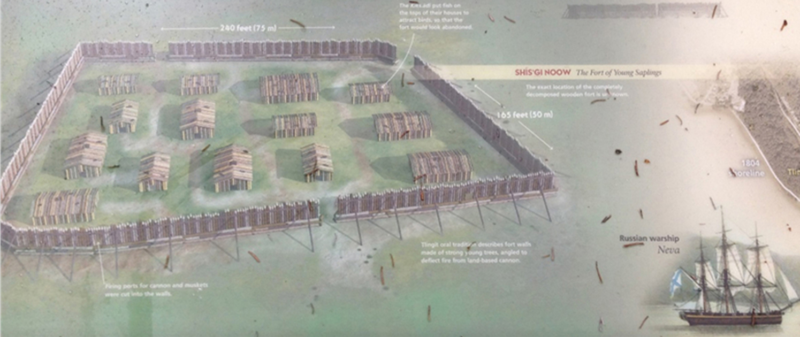
    Enlarge / This interpretive sign at the presumed "fort clearing" includes a reconstruction of what the fort probably looked like in 1804. (credit: National Park Service )

    In 1804, Tlingit warriors sheltered behind the walls of a wooden fort on a peninsula in southeastern Alaska, preparing to repel a Russian amphibious assault. An archaeological survey near the modern community of Sitka recently revealed the hidden outline of the now-legendary fort, whose exact location had been lost to history since shortly after the battle.

    The coolest battle you never heard of

    The Tlingit had already sent Russia packing once, in 1802, after three years of mounting tensions over the Russian-American Trading Company (a venture akin to the better-known British East India Company), which had a presence on what’s now called Baranof Island. Because the Tlingit elders—especially a shaman named Stoonook—suspected that the Russian troops would soon be back in greater numbers, they organized construction of a fort at the mouth of the Kaasdaheen River to help defend the area against assault from the sea.

    By 1804, the Tlingit had procured firearms, shot, gunpowder, and even cannons from American and British traders. They had also built a trapezoid-shaped palisade, 75 meters long and 30 meters wide, out of young spruce logs, which sheltered more than a dozen log buildings. The Tlingit dubbed it Shis’gi Noow—the Sapling Fort.

    Read 17 remaining paragraphs | Comments

    index?i=4i--Ie0e9og:hVqwDGcTC0o:V_sGLiPBpWUindex?i=4i--Ie0e9og:hVqwDGcTC0o:F7zBnMyn0Loindex?d=qj6IDK7rITsindex?d=yIl2AUoC8zA
    • chevron_right

      Radar reveals a feasting hall near a Viking ship burial

      Kiona N. Smith · news.movim.eu / ArsTechnica · Saturday, 14 November, 2020 - 13:15

    In June, archaeologists began unearthing a Viking ship from a farmer’s field in eastern Norway. The 1,000- to 1,200-year-old ship was probably the grave of a local king or jarl, and it once lay beneath a monumental burial mound. A 2018 ground-penetrating radar survey of a site called Gjellestad, on the fertile coastal plain of Vikiletta, revealed the buried ship.

    The Norwegian Institute for Cultural Heritage Research, or NIKU, announced the ship find in 2018, and it announced earlier in 2020 that excavations would begin over the summer to save the vessel from wood-eating fungus. NIKU archaeologist Lars Gustavsen and his colleagues’ recent study is the first academic publication of the survey results, and it includes the previously announced Gjellestad ship burial as well as the other ancient tombs and buildings. In the recently published paper, the radar images reveal the ghosts of an ancient landscape surrounding the royal tomb: farmhouses, a feasting hall, and centuries of burial mounds.

    Altogether, the buried structures suggest that over several centuries, from at least 500 BCE to 1000 CE, an ordinary coastal farming settlement somehow grew into an important seat of power on the cusp of the Viking Age.

    Read 16 remaining paragraphs | Comments

    index?i=VfH8aL0-yWI:oVIFEo32gdc:V_sGLiPBpWUindex?i=VfH8aL0-yWI:oVIFEo32gdc:F7zBnMyn0Loindex?d=qj6IDK7rITsindex?d=yIl2AUoC8zA